Using Google Earth to Scout New Lakes
3 ways Scott Martin leverages new technology to prepare for bass tournaments
Google Earth is one of FLW Tour pro Scott Martin’s go-to tools for scouting new tournament fisheries. The former FLW Cup champion and FLW Tour Angler of the Year relies on the satellite imagery before and during practice and competition days for everything from getting a “big picture” feel of a lake to locating specific grass beds, docks and laydowns to fish.
Martin doesn’t follow a strict step-by-step process for tournament preparation, but his advice for incorporating Google Earth into his pre-tournament program can help any angler who’s preparing for a new fishery or an old one at a new time of year. Here are three ways he uses it.
1. Get the big picture, start faster
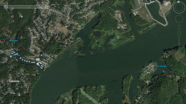
One of the biggest advantages of Google Earth, and the way Martin uses it to begin his research, is to learn about the overall basic features of a lake. It’s like putting a set of eyes on the fishery, without actually having to be there.
“For me the advantage of going through satellite imagery, especially on a lake I haven’t been to ever or not in a while, is when I fly around on my computer and I look at the shoreline and I look at trees and docks and bridges, I’m seeing it with my own eyes. When I get there two weeks later or a week later or whenever, I feel like I just recently was there,” Martin says. “That first day of practice, if you don’t do those things beforehand, when you launch your boat you’re kind of lost. When you drive around you’re taking it all in for the first time, versus focusing on where the fish are. I already know where there are docks or rocks, where the bank is steep or shallow.”
2. Match tournament history with satellite research
Martin’s tournament prep always begins with some exploration into tournament history to get an idea of what kind of weight will be needed to win, techniques and baits that worked in the past, and the types of patterns that are in play for the time of year he’ll be fishing. He also looks for information about lake conditions during those previous events.
Once he’s gotten his general overview of the fishery using Google Earth, Martin starts scouting for areas that fit what he learned from past tournament results.
“I look at past water levels on Google Earth going back through previous years,” he says. “I’m seeing where they might have had a drought or flood. I can then see what areas stay dirty or clean. And I can see how the water moves – the current. That gives me a really good feel for how things migrate through that lake.”
He’s just careful not to get too focused on one area, and to keep an open mind once he actually gets started on the water.
“I don’t want to make my mind up on a whole lot of anything,” Martin says. “I’m looking for generalities – water levels, clarity – to just get a feel for a lake.
“Then when it’s time for me to get on the water, I really ride around a lot. I spot-fish; a little bit here, and a little bit there. I don’t want to stay in an area too long even if I like it.”
3. Locate specific target areas
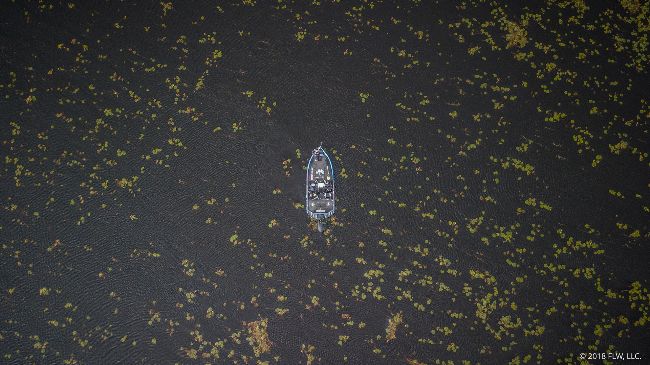
Once Martin has uncovered a productive area or a pattern – whether in practice or the tournament – he’ll use Google Earth to expand on it or eliminate unproductive water. It increases his efficiency.
He might use it to scout other nearby or similar creeks to see what’s there, or to locate more of the types of structure and cover he’s learned hold fish from his on-the-water practice. Or he might study the way current flows through a system to see which of his spots are most likely to be blown out during a heavy rain.
“I dive further in and look for irregularities that might not have even been on a map of any sort,” he says. “At La Crosse [in 2017] I’d say half of the fish I caught came off two wing dams that I had no idea were even there until at the [rules] meeting, when I was looking at my phone to see how to navigate to where I wanted to go. I zoomed in and saw two wing dams that were underwater because the water was lower in the photo. I literally fished right beside them [in practice] and didn’t even see them.
“Throughout the Cumberland tournament [in 2017] when I won, I went home every night and fell asleep with my computer open,” Martin recalls. “I was looking for the right kind of bank. It let me eliminate water quickly.”
Martin has also used Google Earth to bail him out. At a tournament on Lake Dardanelle, after two tough days of fishing, Martin knew he needed to fish new water. Using the satellite images, he located a backwater two pools away on the Arkansas River, in an area about as far from takeoff as he could get, and a bank littered with laydowns. Martin ran all the way there, fished the laydowns and earned $10,000. That kind of gamble might not have paid off had he run down there not knowing a good starting point, or had he not been using Google Earth as an extra set of eyes on the fishery.