2-D sonar strategies
How to use this old-school sonar to find fish-holding structure
(Editor’s note: This article originally appeared in the 2014 March issue of Bass Fishing magazine. To read more compelling articles from Bass Fishing magazine each month, become an FLW subscriber member. If you’d like to sign up for a digital subscription to access articles online, click here).
Electronics have become the great leveler of the bass fishing playing field.
There was a time when experience almost always trumped equipment when it came to finding fish. If you wanted to be a better fisherman, you got out there on the water and paid your dues. You learned the spots that produced at certain times of the year, and culled the 90 percent of the water that was almost always void of bass.
The last decade or so of fish-finding technology has changed the paradigm, however. Now anglers can buy a Lowrance HDS unit, cruise likely looking spots on any lake and literally see bass.
Still, just having one of the computer-age units doesn’t guarantee you’ll become the next Forrest Wood Cup champion. You must learn how to incorporate the equipment into each fishing scenario. You have to determine when best to use traditional 2-D sonar, or DownScan or StructureScan. You have to understand the limitations of each, and the situations where each excels. And then you have to put them to use in an efficient way that balances your “search time” with your “catch time.”
That’s where this feature – the first in a series we’ll be running in 2014 – can help. Throughout the series, we’ll bring you insights from some of Lowrance’s best Walmart FLW Tour pro-staffers and other electronics experts regarding the functionality of the Lowrance HDS system and how modern sonar technologies should be used in real-world situations. This isn’t untested theory; it’s applied science.
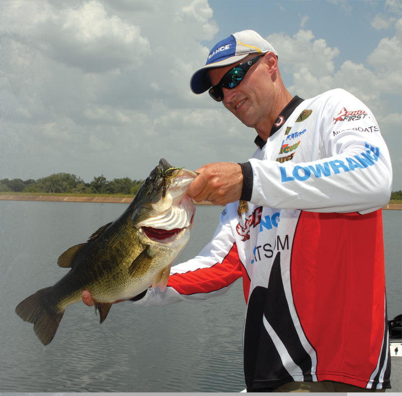
Anglers are most familiar with traditional 2-D sonar, so we’ll begin there, with advice from Kellogg’s Rice Krispies pro Jim Tutt of Longview, Texas, and Todd Driscoll, a Texas Parks and Wildlife Department district supervisor who also works as a Lowrance technician and competes in bass tournaments on the side.
2-D sonar
 Traditional 2-D sonar is the electronics version of meat and potatoes that most of us grew up with. It not only indicates changes in water depth, it also shows structure and cover and, in many instances, how the fish are positioned in relation to it. Driscoll says the 2-D mode is his favorite any time he has a lure in the water, whether he uses it alone or on split-screen in tandem with a mapping chip.
“In my opinion DownScan and SideScan are ideal when you are in the cockpit and in hunt-and-search mode, idling and looking for fish or structure,” he says. “But once I get down to business on the trolling motor – actively fishing – 2-D sonar is my bread and butter. The 2-D image isn’t as detailed as DownScan, but the coverage area is significantly larger because the cone angle that comes off the transducer is much wider. It gives you a bigger picture of what is below the boat.”
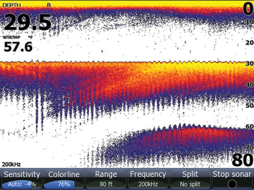
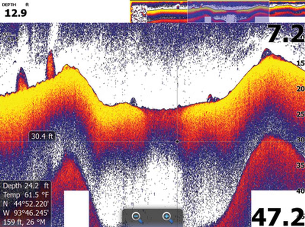
The 2-D transducer works by emitting a circular cone of sound waves that spreads in all directions as it moves downward (the angle varies depending on what frequency you use). As the sound waves move through the water column they bounce off bottom as well as objects such as fish, rocks, brush, etc., resulting in return echoes that are transformed into the information seen on the HDS screen. The hardness of the object reflecting the sound also affects the strength of the return signal, which is what reveals differences in bottom hardness (see the images above) and structure and cover types. Professional anglers are experts at interpreting the subtle differences in returns.
As earlier mentioned, the 2-D coverage area is larger than that provided by DownScan because DownScan sonar emits a narrow horizontal beam that only expands a few degrees from bow to stern, instead of a circular cone. How much larger? That depends on water depth. The shallower the water, the smaller the 2-D coverage area will be and vice versa because the cone expands as it travels down through the water column.
“The trade-off is that the resolution and target separation are much better with DownScan,”?says Driscoll. “A group of fish might appear as a big blob on 2-D, whereas DownScan will produce a real-time picture so clear that you might be able to count the individual fish.”
Part of the reason the 2-D image isn’t as clear is that the return shown on the head unit is a compilation of everything within that expanding cone. Also, if a fish “passes through” the 2-D cone, it continuously creates an arch on the screen until it exits, whereas fish pass quickly through the DownScan beam and create returns that look like small specs.
It’s also worth mentioning that 2-D operates well while the boat is on plane, whereas DownScan and SideScan provide optimum imaging at idle speeds of 2 to 8 mph.
Angles and cones
 While the evolution of StructureScan opened the door to a world of fishing that previously didn’t exist with conventional 2-D, there are certain situations where the old-school technology continues to outshine the new.
Tutt is a big fan of 2-D when he is fishing over grass flats or grass-lined creeks or drainages. He says the cone angle provides him a broader view of what is beneath the boat, which at times might reveal subtle differences about the lake’s bottom that DownScan might not pick up at slow trolling motor speeds or because the signal beam is so restricted.
“The wider cone angle also makes it easier to keep the boat positioned on the edge of the channel,” Tutt adds.
Another situation where Tutt prefers traditional sonar over StructureScan is when he is targeting suspended fish in wide-open deep water using a drop-shot rig, spoon or some other vertical technique where it is essential to make precise presentations, such as when fishing for smallmouths at Lake Erie.
“DownScan might be the deal if the fish are holding tight or stationary to bottom,” he says. “But if they’re suspended out away from rock piles in 40 to 50 feet of water, I think 2-D allows you to see the fish and watch your bait better because of its wider cone angle.”
In the suspended situation, you’re “covering” a larger area with the 2-D sonar cone, especially out in front of the boat, so it’s easier to keep tabs on the fish as they move.
As Driscoll mentioned earlier, it’s rare to see him on the front deck of his boat without 2-D on his screen, regardless if he’s fishing around shallow grass beds near the bank or ridges, ledges and humps far from shore.
“Once I’m done hunting and searching with StructureScan and I know where I’m going to fish – either because I saw fish or a certain type of structure or cover – I’m going to be in the 2-D mode or 2-D/chart split,” Driscoll says. “I might go to a 2-D/chart/DownScan split for a little more clarity if I’m on the move with the trolling motor on high speed. But I’ll never substitute DownScan for 2-D altogether while I’m fishing.”
Search and hunt: Tutt uses 2-D for speed
 Want to put some hours on that outboard? Buy a Lowrance HDS unit equipped with StructureScan. You might not be able to resist the temptation to idle around for hours scoping out all sorts of cool underwater structure that you previously didn’t know existed.
Lots of guys are doing it these days, but Tutt tries to resist the inherent idling bug whenever possible. To him, the hours spent searching are a blend of high-speed looking with 2-D and more careful studying with StructureScan.
“When I’m practicing, I like to cover as much water as possible in the time allowed, especially on a lake I’m mostly unfamiliar with,” Tutt explains. “I can’t do that by idling around for six to eight hours a day.”
While Tutt’s search-and-hunt regimen on a new lake will almost always involve the use of StructureScan at some point, he usually prefers to scan potential sweet spots with a 2-D/chart split first.
“The 2-D will give you a good reading with the boat moving at speeds up to 40 mph,” Tutt says. “I’ll usually have a pretty good idea what I want to look at before I get to the lake by looking at my maps. If it’s a lake with a lot of points, ridges, humps, creeks, etc., I’ll zigzag over those places on plane. If I see something that interests me on 2-D, I’ll pop a waypoint and then go back and pick it apart with StructureScan.”
Tutt says he’ll approach ledge lakes or impoundments he knows extremely well with an entirely different strategy. For instance, on a classic ledge lake such as Kentucky Lake he’ll spend a lot of time in the chart/2-D mode idling straight along the breaks, then switch to StructureScan immediately when he sees something he likes.
“You have to slow down on those Tennessee Valley lakes because there’s so much along those ledges that has the potential to be good,” he explains.
On his home lakes of Toledo Bend and Sam Rayburn, Tutt says there is no need in running around looking for stuff that he already knows is there.
“I know most of the areas that are historically good, so I can go straight from spot to spot and check them out with a chart/StructureScan split immediately,” he says. “That saves me a lot of time that can be better spent elsewhere.”
Managing and organizing waypoints
If you like Lowrance HDS Touch units, you’ll love what they can do when it comes to waypoint management and organization. To hear Cutter pro Cody Meyer of Auburn, Calif., tell it, the processes have never been easier.
“It’s a really awesome feature, especially for guys who visit a lot of different lakes and mark 2,000 to 3,000 waypoints over the course of a couple of seasons,” Meyer says. “With HDS Touch you can actually go to a lake and mark a whole bunch of waypoints, then save all or some of those waypoints to an individual SD card specific for that lake or an area of that lake with a touch of an icon. Then you can go back in and delete the original waypoints off your unit just as easily. Not only does this allow you to keep your waypoints neatly organized by lake, but it also makes it easy to prevent your unit from getting cluttered up with too much data and keep it operating at optimum speed.”
Meyer suggests stocking up on SD cards and storing them in a waterproof Plano StowAway. Label each card by box or region. When he revisits a lake, all Meyer has to do is pull the correct SD card from his files, upload them into his unit and he is ready to go fishing.
Here’s how to save Lowrance Waypoints, Routes and Trails on HDS Touch units.
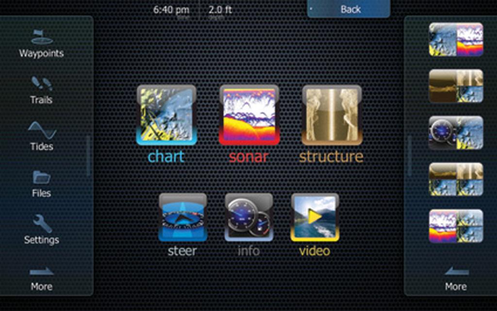 1. Hit the Page button, then select Files.
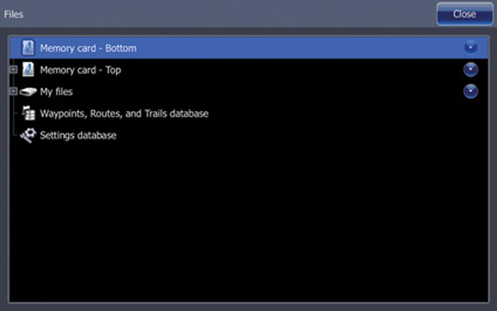 2. Select Waypoints, Routes, and Trails database.
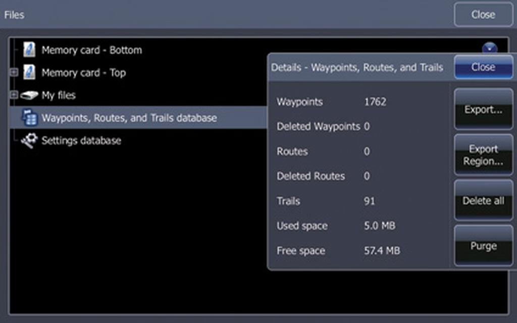 3. Select Export to save all information. If you want to save only the information from one lake or one region, select Export Region. An orange box will appear on the Chart. Drag the orange box around those waypoints, routes and trails that you want to save separately. Only the information in the orange box will transfer to this file.
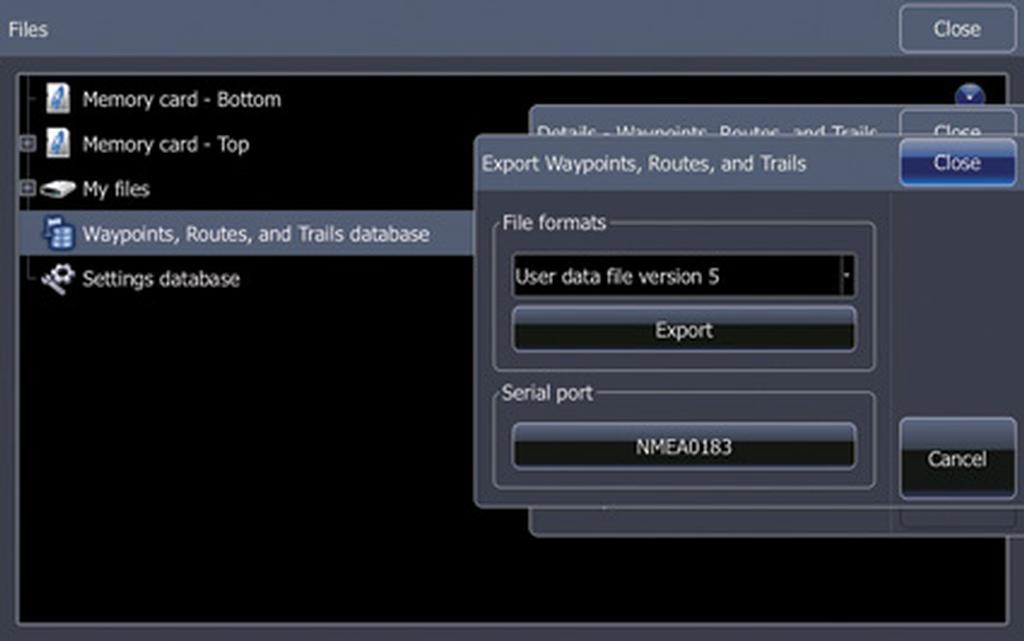 4. Select the data file version. Version 5 is default on HDS Gen2 Touch units and is compatible with both Gen2 and Gen2 Touch units.
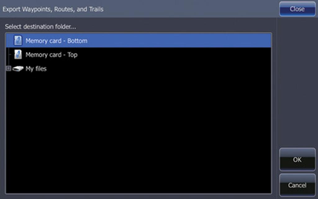 5. Select the destination of your saved file, either to a memory card or to the internal memory on the unit (My Files). Press OK.
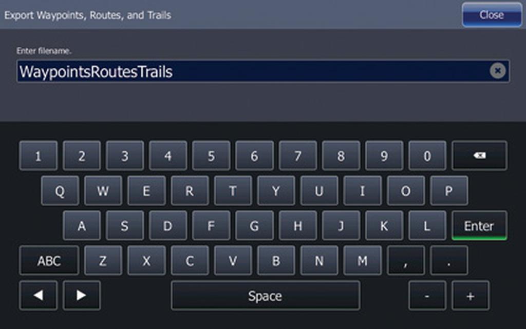 6. Name the file. The default file name is WaypointsRoutesTrails, but you can customize the name. When you select Enter, an hourglass symbol appears, indicating the unit is saving the file. When the hourglass disappears, the file has saved.
(Editor’s note: The preceding article represents Part I in the FLW Bass Fishing magazine Electronics Education Series. Coming next month: Part II – DownScan strategies.)